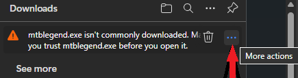
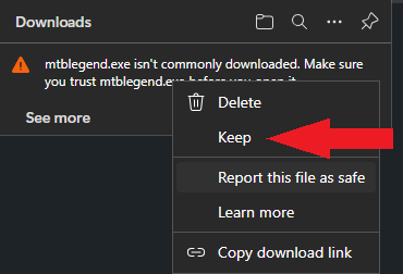
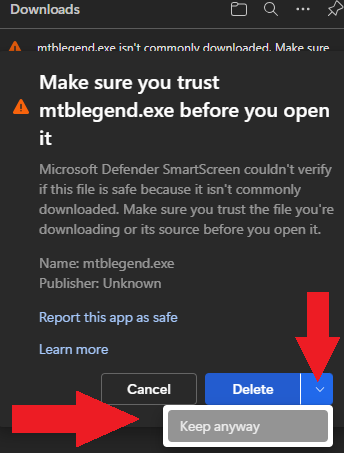
Video Tutorial how to send the maps. For more Video Tutorials explaining all the basics go here: https://www.velomap.org/tutorials/enbeginners-starting-guide-dewo-beginnen-tutorial/ Maps are available Worldwide. They are usually updated every Friday. All maptiles are compiled with mkgmap using map data from openstreetmap.org & Contributors. You can use and edit the map data by visiting openstreetmap.org. Thanks to Geofabrik for providing the map data snapshots which I use to create the maps. Thanks to http://viewfinderpanoramas.org for the best DEM (contourlines) available on the net. -- For Copyrights please see the Installer or if you unextract the installer see the file copyright.txt. Contourlines/DEM data: The altitude data for the contourlines is from varying sources in the following priority (if available): more exact info which data is used where - inside the copyright.txt files. Besides being shown on (nearly) all Garmin GPS devices - most People will use Garmin Basecamp (v3 or later) or Garmin Mapsource to show the maps on their Desktop and plan tours/trips. For anyone on the good side of earth Velomap / Openmtbmap maps are also correctly shown in Qlandkarte_GT - QLandkarte_GT is compatible with all big OS (Linux, MacOSx and well Windows too). Linux users can alternatively install Mapsource 6.13.6 in WINE. After unpacking you find instructions for Qlandkarte / Linux use in a .txt file (informations... .txt). For Linux/Unix users there is also a script to unpack the maps, and automatically create a gmapsupp: https://github.com/btittelbach/openmtbmap_openvelomap_linux Mapsource - I wouldn't use any version but 6.16.3. Mapsource versions 6.14 to 6.15.6 are complete junk, if you use it, please update. Also note that Mapsource versions prior to 6.16.1 do not show all ways and pathes so they are not really usable. Mac OSx users please use Qlandkarte GT or use the provided Mac OSx maps. Since 11 December I'm using a new individual certification code signing certificate (hosted on google cloud key management service which made it super complicated to employ - as storing certificates on a server is not allowed anymore - so FIPS compliant storage made it a nightmare to get right) - however somehow microsoft is still not recognising it as safe. In the past this worked much quicker. It's sadly still impossible for me to get the Azure cloud signing certificate which would offer instant trust - as it's not available to residents in EU right now. At the same time, I heavily recommend to use neither Norton Antivirus / Avira or Mc Affee - they constantly have false positives so create more danger than not using them. Your best defence is not downloading/clicking on suspicous things and not downloading stuff from shady websites. If not using Windows Defender which I think is pretty good, I would recommend Avast, Malwarebytes, Eset Nod32 or Kaspersky. Download using Microsoft Edge 2. Click on Keep 3. Click on the small arrow on the right - then click onto Keep Anyway If downloaded with any brother other than Microsoft Edge (I highly recommend not to use Edge - better use Brave or Firefox) after double clicking the .exe in your file browser: 2. Click on Run anyway A Beginners Guide can be found here: get started with VeloMaps Install Mapsource: tutorials/install-mapsource/ To install the maps, just run "VeloMap_country_setup.exe". Qlandkarte GT/linux users only need to unzip the .exe maps (7-zip lzma2 compresion e.g. with p7zip) and open the map via Qlandkarte GT (choose .tdb and osmmap*.img). Linux Users also look at this script to unpack/create gmapsupp.img - After unpacking you find instructions for Qlandkarte / Linux use in a .txt file (informations... .txt). Note all installers should work perfectly fine using Wine too. Send Maps to GPS with Mapsource: tutorials/send-maps-to-your-gps/mapsource/ I recommend to always send maps to an external data card and not internal memory. (this way if something goes wrong, or maps would be damaged you run less danger of wrecking your GPS). Alternative: Use create_gmapsupp.img.bat or create_gmapsupp.img_with_mkgmap.bat and place the newly created gmapsupp.img into /garmin folder on your GPS. Address search cannot be included this way. Send maps to GPS with mkgmap (for Unix users): tutorials/send-maps-to-your-gps/mkgmap/ You can also send maps to your GPS with QlandkarteGT Mapsource Error / debug Mapsource: There is a problem with the MapSource registry. Please re-install Mapsoures and start again Solve with Mapsource Fix Or with Mapset Toolkit Please also read the FAQ - General: Autorouting over (very) long distances on GPS works only with Via Points. If you plan your routes on a PC solve this issue with WinGDB: plan-routes/ - Autorouting needs attributes like tracktype, lanes, routes, smoothness, class:bicycle and others to work well. So keep care to enter those details into OSM. (not all are needed, but enough for me to guesstimate wheter a street is cyclefriendly/mtbriendly or not). - Non Connected ways and overlapping ways without node, this is the main problem and a problem of the underlaying map data – please check here: http://keepright.ipax.at/report_map.php Only check/enable: "allmost Junctions" , "intersections without junctions" as well as "overlapping ways". This helps you to quickly spot the erros. You can then follow the link to Potlatch (or also JOSM is integrated for JOSM users) and quickly correct mistakes! Watch out not to connect ways that are not connected in reality (i.e. a way crosses another on a brigde, here no connecting node is the right solution). - If you use Windows 2000 you need to install the "reg" command : Reg cmd at Microsoft if you want to run the batchfiles (.bat files). The Batches are incompatible to earlier Windows versions. - Note sometimes sea is missing or lakes empty. It is usually a problem in OSM data. - Note 1: older GPS (non touchscreen) run slower the more maps are inside memory. For 60CSx or Vista/Legend HCx I recommend to not use more than 2 GB of maps, else your GPS gets slow. While you can join maps of different countries, routing over the boundary is a bit shaky, and you will have one map overlaying the other with white background. As long as mkgmap cannot create randomly shaped overview maps (currently only rectangles), this problem is not solvable. There is however the possibility to download a Europe map, which will be updated every 4-6 weeks. If you install an openmtbmap and a VeloMap of the same country with contourlines as separate download (and Spain as well as Canary Islands), you should only send the contourlines once (meaning with either Openmtmbap or Velomap of the country). Else you GPS might not show the maps, or worse not even start until maps are deleted. There are several possibilities. a) Install both maps without contourlines and contourlines separately (install separate contourlines only map option in installer). You have not trouble. b) be careful here: Select the map as usual in Basecamp/Mapinstall, then go to the list of the selected tiles ready to be sent to the GPS, scroll down to the bottom, and unselect the contourlines only tiles from the list. -- This is not a problem with countries where contourlines are fully integrated like Germany, Alps, Austria,...... Just run the velomap_country_setup.exe again. While you can join maps of different countries, routing over the boundary is a bit shaky, and you will have one map overlaying the other with white background. As long as mkgmap cannot create randomly shaped overview maps (currently only rectangles), this problem is not solvable. There is however the possiblity to download a Europe map, which will be updated every 4-6 weeks. Get Europe Map here (donation needed): www.velomap.org/support/europe-map/ On installation you can choose the layout of the maps. Traditional layout is for Qlandkarte GT, Mapsource and Basecamp and offers a good layout and design for big screens. On the GPS device velo.typ offers high contrast for best orientation while riding your bike or walking. For riding your roadbike, or commuting I have included the "racing bicycle" layout. The Racing Bicycle layout is heavily simplified, and focusses on the street network. Buildings or other distracting objects are not shown. Also most POI are not shown. In order to change the layout - simply run velomap_country_change_layout.exe (this is also linked in your Start --> Programs Folder for each map). This also enables you to quickly change the layout before sending maps to your GPS device, and then quickly change it back for better planning on your desktop. You can change .TYP-files - which are responsible for the layout, and therefore the map colours, to your liking by using MapTK to adapt the .TYP files. Do not use because it is not fully compatible and may corrupt the .TYP file. Unicode is needed to display several alphabets in one map. Non Unicode maps can only display a single alphabet - e.g. kyrillic and latin - but not both. However Garmin blocked using Unicode maps in part of a broken copyright protection on newer GPS device series. In general just download the Maps from the first "VeloMap" tab - they are in Unicode if useful. Some maps by default are in Unicode. You can identify them by (Unicode) note behind the name - alll countries/maps not listed on the "Non Unicode" tab are anyhow Non Unicode. If you get the message - "cannot authenticate maps", and you have you have one of the following devices: you will need to download the "Non Unicode" version of the map instead. So get the map from the "non unicode" VeloMap tab instead. Only maps of regions where several different scripts are used - are in unicode. If Latin is the predominant script - then of course no unicode map is offered. If your device can display Unicode maps - then of course get the standard version - meaning Unicode. Note1: if you install the non Unicode version of a map - you will overwrite the Unicode map. You can only have either or installed. Note2: The contourlines are identical for openmtbmap/velomap and unicode or non unicode. You only need to download the contourlines once. On updates it's enough to re-download and reinstall the map installer. Garmin Edge x30 or newer Garmin introduced a completely broken high contrast mode - that washes out the colors of the maps. Either disable the high contrast mode on the map visibility section. Or delete the \Garmin\MapThemes\Mountain.kmtf (sometimes also called \Garmin\MapThemes\Mountains.kmtf ) file (back it up if you think you ever want to use that mode. Since the newest firmware in July 2021 you need to enable classic mode - , select a profile, and select SD Cards This is not about the maps but in general Garmin units that have a microSD card slow only accept SDHC cards - SDXC cards will not work. Max 32GB size and you need to format it with FAT32 (not exFAT). Be careful with 32GB cards which are available as both SDHC and SDXC. 16GB and smaller usually are always SDHC. Default - Local Language Unicode. All labels / street names are exactly like in the name tag of OSM. Note for any country that uses latin - the default will be latin1 and the options below are not available. An exception is the South America continent map that is additionally available in English Non Unicode. For USA/Canada this is also the only option. For European countries using latin if you want the English version - you can use the European continent map that is available in English versions. English Unicode: If available in OSM - English or other European language translation is used. If no translation is available in OSM, the local name tag is used. Local Language Non Unicode: Same as default but instead of Unicode the local codepage is used. So some characters may need to be transcribed automatically in creation. Codepage is always the local default codepage. English Language Non Unicode (always latin1): If available English or other European language translation from OSM is used. If not names are transcribed to Latin. Please comment if you like theese maps or even better tell other people about them (forums, blog about it, twitter, etc…) In case maps break Mapsource or don't work – please write exactly which downloads don't work and the time of download as well as your OS and Mapsource version.. Please also read here https://www.velomap.org/download/#problems-help-tutorials or in the FAQ Maps are updated once weekly - usually Thursday-Friday. In order to see the last update time, or check the exact filesize (or md5 checksum) - just click on the MD5 link that follows each download. For some countries contourlines (height lines) are available as separate downloads – please get them from the contourlines tab. They are only available for VeloMap Members Most countries, especially the popular ones, have the 20m contourlines already integrated. However for several countries the contourlines are rather large (rule of thumb if contourlines have more data than the maps) and I integrate them, but you need to download them separately (once). The installer will ask for the contourlines file as soon as you activate the checkbox to integrate the contourlines in the installer. You do not need to extract the contourlines - this will be done by the installer (and is only needed once. On updates you don't need to redo it). In general it is fine to only update the map, as I try to change the contourlines as seldom as possible. The 10m contourlines always have to be once downloaded, and the installer will ask for them if you chose to install them. Some maps by default are in Unicode. You can identify them by (Unicode) note behind the name - alll countries/maps not listed here are anyhow Non Unicode. You will need to download the Non Unicode Version if you have one of the following devices: This is due to a firmware bug that Garmin introduced as part of their efforts to cut down on people "pirating" their maps. However by doing that they also cut down on Unicode maps produced by mkgmap or even some of their old (legitimate) maps which are not running anymore on these devices. You will know that you need to use the Non Unicode map if on boot your GPS device tells you to "unlock maps". Why is the Europe Map in Unicode? Well for example in Greece and some Eastern Europe countries the script is Cyrillic not latin - and only Unicode maps can contain both scripts in one map. So the non unicode map will not correctly show labels in such countries. Use the country non unicode map instead. They are always in the predominant script of the country. Note: if you install the non Unicode version of a map - you will overwrite the Unicode map. You can only have either or installed. Note: some maps have the contourlines as a separate download - the installer will integrate them during install and unpack them. Contourline downloads are the same as for unicode maps. Here only those countries are listed - where the standard download is Unicode. If you don't find a country here - look at the standard downloads. Note - local language maps of: Sri-Lanka, Nepal and Cambodia are in latin1 - so the local language maps are not very useful. There is no ANSI Codepage available (besides Unicode) that would support the script/garmin units. Israel-Palestine map is in hebrew (so the Palestine area is not useful). Afghanistan codepage is for Dari - Pashto is not supported outside of Unicode. Default - Local Language Unicode. All labels / street names are exactly like in the name tag of OSM. Note for any country that uses latin - the default will be latin1 and the options below are not available. An exception is the South America continent map that is additionally available in English Non Unicode. For USA/Canada this is also the only option. For European countries using latin if you want the English version - you can use the European continent map that is available in English versions. English Unicode: If available in OSM - English or other European language translation is used. If no translation is available in OSM, the local name tag is used. Local Language Non Unicode: Same as default but instead of Unicode the local codepage is used. So some characters may need to be transcribed automatically in creation. Codepage is always the local default codepage. English Language Non Unicode (always latin1): If available English or other European language translation from OSM is used. If not names are transcribed to Latin. Your account does not allow you to login into OpenMTBMap website Mac OSx user - just scroll down here on the normal macosx download page: https://www.velomap.org/de/download/macosx/ Gmapsupp.img Downloads are here: https://www.velomap.org/download/premium-gmapsupp-img-directly-for-garmin-gps-units/ Your account does not allow you to login into OpenMTBMap website - However you can download all Openmtmbaps from here for Windows users: https://www.velomap.org/download/openmtbmap/ Mac OSx user - just scroll down here on the normal macosx download page: https://www.velomap.org/de/download/macosx/ Gmapsupp.img Downloads are here: https://www.velomap.org/download/premium-gmapsupp-img-directly-for-garmin-gps-units/ Note if you are not a VeloMap member - please directly go to OpenMTBMap.org About the Maps - Please Read
- Map Data
Programs to Display the VeloMap
Windows Smartscreen / Microsoft Edge / Norton

Problems – Help – Tutorials
Current Issues
Overlapping maps in border regions
Velomap and Openmtbmap of the same Country -- Problems
Notice on Updating Maps
Overlapping maps in border regions
Change Layout and Contrast of the maps
Compatibility - Standard (Unicode) vs Non Unicode (cannot authenticate maps)
Language and Codepage
Feedback
Map Downloads by GWDG
Contourlines Premium Downloads
Non Unicode Premium Maps - Only offered for Non Latin Using Countries
Language and Codepage
Velomap (and Openmtbmap) Premium maps download in Mac OSx format (gmap)


Hallo,
zunächst einmal vielen Dank für die tollen und zuverlässigen Karten! Fahre seit Jahren danach 👍
Im Moment versuche ich die aktuelle (23.08.) Version der non-unicode europe zu laden, aber die veloeurope.7z matcht nicht mit den Angaben aus dem md5 file, es scheint noch die alte Datei vorzuliegen. Kannst Du ungefähr sagen, wann die neue veloeurope.7z da ist? Ich fahre demnächst auf Tour und es wäre toll, wenn ich die frische Karte mitnehmen könnte (und die Planung da nochmal verifizieren).
(31.08.2025, 22:19)
$ curl -sI https://www.velomap.org/wp-content/mapdownloads/nonunicode/veloeurope.7z | fgrep content-length: | cut -d’ ‘ -f2
16122648327
Danke, Oliver
In etwa 12-16 sollte eine neue Version von Morgen online sein.
Super, danke für das schnelle Reply!
Ich hab jetzt die neue Version 01.09. vom Installer und es ist auch eine andere Version der veloeurope.7z da, die matcht allerdings nicht das md5sum und Größe aus der md5-Datei und kann auch nicht installiert werden. Die aktuell downloadbare veloeurope.7z hat die Größe 16242514439 und md5 d438748a13721890badd0968d3cbf309
Ja, Größe und MD5 Checksum passt doch überein:
https://www.velomap.org/wp-content/mapdownloads/nonunicode/md5_hashes/veloeurope.7z.txt
MD5 Checksum:
D438748A13721890BADD0968D3CBF309 veloeurope.7z
date last modified and Filesize in bytes
01.09.2025 06:44 16242514439 veloeurope.7z
Ah, die exe hat sich nochmal geändert, jetzt passt alles und installiert! Top und Danke!
I have problem with the VeloMap of Thailand. I can download & install it to BaseCamp. Everything works fine there. I tried to install the map to my Garmin device(Edge 1030), it showed the installation successful. But I can’t find the map in my Garmin device. Why? I am your member for over 10 years. I did the same thing a couple times every year for different countries and I never have problem like this. Can you help me?
Are you maybe using the unicode version? You will need the non unicode version of Thailand
Hallo,
ist die Entwicklung der VeloMap Europa eingestellt? Der letzte Update lt. MD5 ist der 07.03.2024, oder informiere ich mich falsch?
Gruß
Ich werde sie bald updaten – ich habe wegen der Edge 1040 Problematik mit dem neuesten Firmware Bug bisher auf ein Update noch verzichtet.
Hallo, nur ne kurze Frage zur Thüringen-Karte: Hat es was zu sagen, dass ausgerechnet vor Thüringen ein Term “mtb” steht? Die Downloaddatei heißt velothueringen.exe. Das “mtb” irritiert ein wenig, weil man diesen Term “mtb” eher auf der openmtb-Seite erwartet. Tritt übrigens nur bei Thüringen auf.
Kein Problem also, nur Kosmetik 😉
gruß reinhard
Ah, da habe ich beim copy/paste der Links einen Fehler gemacht. Ist korrigiert. Ist nicht so easy die Links alle korrekt zu haben mit den zig Versionen und Sprachen der Website.
Hello,
First, many thanks for your work that helps me cycle around the world since 2014 🙂 !!!
I’m trying to install velohamburg.exe but I cannot find the 10m contourlines. And I cannot install the map without them.
Thanks in advance for your support and kind regards
Gilles
sorry, there is a bug in the installer. For Hamburg and Berlin actually the 20m contourlines option is 10m contourlines and they come included in the download.
It’s hard enough to find the 10m contourline in Hamburg however as most places are below 10m….
Hello,
Don’t be sorry for anything ! Thank you for the quick answer, it works perfectly 🙂
Kind regards
Hallo, bei welchen aktuellen Garmin Geräten lassen sich die OSM heute noch navigieren (SD Schacht)
Grüße Manfred
Mit SD Schacht gibt es kaum mehr aktuelle Geräte – Navigation geht aber auf quasi allen neuen. Empfehlenswert je nach Preis sind weiter Oregon (halt schon alt aber mit SD Karte) bzw Edge 1040 sowie Edge Expore 2 (im Prinzip fast ident zu 1040 nur kleinerer Akku, kleineres Display und etwas weniger Sportfunktionen. System/Prozessor ist identisch) – auf keinen Fall Edge Explore (also der alte).
Hi – you refer to QLandkarte_GT as a program that can display VeloMaps. QLandkarte_GT has now been discontinued and replaced by QMapShack.
yes I know – but it’s still working on most systems, no? And for garmin maps I really think it’s superior to Qmapshack. Qmapshack not reading mapset.tdb style maps anymore and instead only gmapsupp.img type was the wrong decision IMHO.
Hallo,
wollte velo europa aktualisieren. Der Installer beharrt darauf Höhenlinien mit dem Namen “veloeurope.7z” verarbeiten zu wollen. Gefunden habe ich aber nur “windows_contours_europe20m.7z”.
Was mache ich falsch?
Gruß Gerd
Die veloeurope.7z ist direkt nach dem enstprechenden veloeurope.exe Download verlinkt. Diese muss gleiche Sprache/Unicode und Datum sein wie die velourope.exe (ansonsten wird dre Installer Fehlermeldung anzeigen.
Danke für die Antwort.
Ich habe jetzt mehrfach die veloeurope.exe herunter geladen. Firefox meldet den Abschluss des downloads und das wars. Keine Verlinkung, kein Hinweis. Ich bin zu doof.
du brauchst sie nicht mehrfach herunterladen. Der veloeurope.7z ist eine Zeile drunter (dezidierte Europa Download Seite unter Support) bzw dahinter in der selben Zeile verlinkt (Mapfiles Europe)
Hab mich vom Namen “Mapfiles Europe VeloMap odbl.7z” verwirren lassen. Alles prima. Danke nochmal.
Hallo,
nachdem ich über Paypal gezahlt habe und zurückgeleitet wurde, kam die angehängte Meldung. Hat das was zu bedeuten? Ist das Geld angekommen?
Gruß, Christian
Danke, für die Nachricht. Ich nehme an die Rechnung fehlt. Die Zahlung ist angekommen. Ich kümmere mich Morgen darum.
Hallo.
Ich habe eben auf 2 verschiedenen PCs versucht die Europakarte, konkret europe.7z, herunterzuladen.
Und beide Male stoppt der download nach ca. 2,7 GB.
(Der download läuft an sich recht flott, da Glasfaseranschluss).
Was könnte der Grund dafür sein ?
Hier im kleinen Luxemburg fahre ich regelmässig über die deutsche, belgische und französische Grenzen, so dass die EU-Karte doch schon wichtig ist für mich.
MfG.
Michel
Hm, da es auf zwei PCs nicht funktioniert – sehr komisch. Du kannst aber einen Download Manager wie Free Download Manger mit Resume Support nutzen und den Download dann einfach wieder aufnehmen.
Hallo Felix, besteht die Möglichkeit Länder nur teilweise nach Regienen zu installieren. Mein Tablet ist mit dem Speicher ziemlich bei.
Nein – nur für Deutschland gibt es Bundesländer.
Hallo Felix, kann die Installation der Irland oder England Karte auf Tablet Win8.1 nicht ausfuhren, bei ungef. Hälfte der Installation kommt die Fehlermeldung:
Sorry, cannot continue. Please download ireland_contours.7z from http://www.VeloMap.org
die Datei kannst du ja herunterladen – in selben Ordner wie den Installer. Der öffnet sie dann (zumindest unter normalem Windows).
I’ve used VeloMap for several years. I’m happy to donate toward the project.
Thanks, wishing you a lot of fun in the future too with the maps!
Oh man, vielen Dank! Wer lesen kann…;-)
Guten Morgen Felix,
vielen dank erst einmal. Das habe ich soweit verstanden – wo kann ich die separaten Höhenlinien jedoch herunterladen? Ich sehe nur diesen einen von dir zur Verfügung gestellten Link – US-Pacific. Gruß Danny
Genau hier auf der Seite indem du auf den Höhen-Konturlinien Tab klickst.
Hallo Felix,
bei Runterladen der Pacific Karte zeigt er mir beim Installieren folgende Fehlermeldung:
cannot continue, please download windows_contours US-pacific 10m usw.. Die Hessenkarte hatte problemlos funktioniert. Ich habe die US-Pacific-Karte auch noch ein zweites Mal runtergeladen.
Wenn du bei der Karte die Höhenlinien auswählst, dann musst du die Höhenlinie auch separat herunterladen – selber Ordner wie der Download – und dann beim installieren auswählen. Die 10m Höhenlinien sind dazu nie integriert – und immer ein extra Download.
Is there a map for Guyana, and Caribbean Islands(e.g Antigua and Barbuda)?
The continent map of if South America
Antigua y barbuda is not in the Southamerica map. Could it be that it is in Central America?
Yes!
Is there away to combine a 2gb and a 1gb map img?? I keep trying but get the error message say the two files are greater then 4gb!!!
Why do you want to combine the maps? And how do you combine them? Please say exactly what your are doing / sending/ combining so I can try to help you.
Combining Contours etc with main gps image using the Bat file in the zipped downloads. I also like to add my own IMG files I have created from GPX files such as the Complete Bothy/Mountian huts from UK and Europe and a few others. This can be around and extra 120megs… Works fine with Bat file as long as ALL img files are below 2gb when combined yet if it goes over it gives the error as stated even though you are suppoes(according to bat file) be able to combine upto 4gb of IMG files..
Sorry – you will have to open up the bat and change the tests or find out why it doesn’t pass through – the bat file have some tests and conditions that need to be met – and likely your .img does not fulfill them.
Or you use gmaptool manually.
I cannot offer further support for this. But only very old Garmin GPS units only support a single gmapsupp.img anyhow.
I know only only ones do. But even Newer Garmin devices limit the amount of MapIMGs. ANd I like others will have quite a few always installed lol… Most of My GPSrs and watches have 12-14 always installed(depending on storage) hence combining some allows for more when needed.
And yes I know you will find it excessive to have that many on. But am and Outdoor instructor and work world wide as well as a team leader in SAR too.. So Don’t have the time to always switching maps in and out of devices…
Anyway Had actually foud GMPtools and already started using it before you had replied. But thank you for taking the time to respond.
Should have said “I Know Only older ones” at the beginning lol
I did not know they limit the amount of gmapsupp.img files – they do limit the amount of maptiles – which will not change whether or not you combine gmapsupp.img files together. Also as boot and search becomes slower – I usually recommoned no more than 6-8GB of maps (excluding contourlines) per device – exception being the 2022 generation devices like edge 1040 / likely explore 2, and Fenix 7 / Forerunner 255 which have much faster processors/memory.
General its 3500-4000 tiles I believe… Not really ever had an issue thankfully with speed even on my Fenix 5x which has 12 maps around 11.5gb in size on at the moment and my oregon 750 and montana well lets not go thereon how much is on them but it requires over 30gb ;-).. But I’d get what you mean that it could be come slower…
The coast line of Singpaore seems to be broken, I’m not sure is my setting is incorrect or it’s a problem of the map.
I will update the coastline data for this weeks updates. It sometimes happens – that the coastline is broken in some countries.
Hallo,
SW und NO mit Höhenlinien – alles gut. Allerdings habe ich gedacht … wie bisher: zuerst die *.exe starten und nach der Installation die zip-Datei entzippen und einfügen oder so. Man muss halt die Anleitung genau lesen :-).
Vielleicht doch ein Hinweis, der manche Mail überflüssig macht.
Vielen Dank
Horst Groos
Der Installer weißt doch auf darauf hin, manuell entpacken war zuletzt vor gut 10 Jahren.. Seitdem macht es der Installer.
Hallo Felix,
ich wollte heute die Europakarte updaten. Ich habe mir die dafür erforderlichen 3 Dateien heruntergeladen. Kurz nach dem Starten der Installation durch Doppelklick auf veloeurope.exe bekomme ich beigefügte Fehlermeldung. Keiner der in der Fehlermeldung genannten Gründe ist zutreffend, das heißt Speicherplatz ist frei und keines der genannten Programme (Basecamp, etc.) ist geöffnet. Was mich wundert ist, dass die veloeurope.exe nur 6599 kB hat. Kannst Du den Sachverhalt bitte mal überprüfen.
Dank und Gruß!
Ritzelfuchs
Die Größe ist okay – da die Daten quasi alle in den .7z Dateien liegen. Kommst du zu irgend einem Auswahlmenü beim Installer? Oder ist dies das erste was du siehst? Wenn es das erste ist – starte den PC mal neu – bzw öffne den Installer aus einem anderen Ordner heraus – ist mir etwas rätselhaft wenn die Programme alle geschlossen sind.
Nach dem Start der Installation werden die Auswahlmenüs normal abgefragt. Nach Abschluss der Auswahlmenüs muss man auf “install” drücken und dann kommt obige Fehlermeldung. Neustart des PC’s oder starten der veleurope.exe aus einem anderen Ordner bringt das gleiche Ergebnis.
Gruß
Ritzelfuchs
Hier das Programmskript zum Zeitpunkt der Fehlermeldung. Vielleicht hilft das weiter.
Gruß
Ritzelfuchs
Nachdem ich den von früheren Installationen bereits vorhandenen Installationsordner C/Garmin/velomap/europe deinstalliert hatte, ging die Installation ohne Probleme.
Gruß
Ritzelfuchs
der Installer hatte scheinbar nicht volle Schreibrechte – wieso auch immer.
Hallo,
ich abe die europa Karte deinstalliert ( beide veloeurope und auch mtbeurope ).
Der Fehler kommt immer noch.
Wie realisiere ich dies:
Wenn nicht musst du mit mapset Toolkit den Eintrag entfernen.
Vielen Dank für die Hilfe
https://accounts.google.com/v3/signin/identifier?dsh=S-1508924936%3A1680271685640781&continue=https%3A%2F%2Fsites.google.com%2Fsite%2Fsites%2Fsystem%2Ferrors%2FWebspaceNotFound%3Fpath%3D%2Fcypherman1%2F&followup=https%3A%2F%2Fsites.google.com%2Fsite%2Fsites%2Fsystem%2Ferrors%2FWebspaceNotFound%3Fpath%3D%2Fcypherman1%2F&ifkv=AQMjQ7Q1QkXhUFa23c4fjt-gAPHsehjoCLaTVj65Lt78sZwGDD7sI3lpRt94qLt22w23c8TAlH78LA&passive=1209600&service=jotspot&flowName=GlifWebSignIn&flowEntry=ServiceLogin
Look for errors , or look for the map on the right then uninstall.
Du hast irgendwas falsch gemacht beim updaten
Bzw separate 20m Höhenlinien Karte im installer auswählen könnte das Problem auch beheben
Servus, ich versuche wieder mal, ganz Europe runterzuladen. Leider bekomme ich bei Map & Contour nach einiger Zeit “network error” – vermutlich, weil die Dateien zu groß sind? Und mit den URLs (z.B. https://www.velomap.org/?s2member_file_download=odbl/europe_contours.7z) meinen Downloadmanager nicht nutzen.
Gibt es irgendeine Möglichkeit, die direkte URL hier zu bekommen um das mit einem Downloadmanager zu versuchen (vermutlich schwierig, da sich ja dahinter der member check verbirgt…)
du kannst die Datei schon mit Downloadmanagern herunterladen – etwa FDM – aber nur wenn du den Link in diese reinziehst (und die das korrekt übernehmen) oder mit Plugin etwa von FDM in Chrome. Evtl hast du aber auch ein Problem mit Antivirus oder etwa .7z Dateien generell (wiederrum antivirus) oder 4GB Grenze am Speicherort.. Network Error ist ewtas unspezifisch.
FDM muss ich mal versuchen. Mein bisheriger Downloadmanager kann die URL nicht auflösen… Leider geben einem die Browser nicht mehr als “network error”, wenn sie ihre Downloads abbrechen 🙁
Leider komme ich mit FDM auch nicht weiter. Bei mir wird in FDM der Link zu einem Download von https://www.velomap.org/?s2member_file_download=odbl/europe_contours.7z zu “index.html” aufgelöst und danach habe ich die Seite auf der Platte…
dann brauchst du die Extension für Chrome (geht auch in Edge und Safari nehme ich an): https://chrome.google.com/webstore/detail/free-download-manager/ahmpjcflkgiildlgicmcieglgoilbfdp
Mit Chrome startet der Download immerhin (in FF funktioniert das PlugIn nicht). Jetzt muss ich nur noch raus bekommen, warum es nach 1.4 GB auch da zu einem “Netzwerkfehler” kommt…
Hallo,
bin seit vielen Jahren begeisterter Nutzer und empfehle immer wieder deine Homepage. Ich habe die schlichte Anmerkung, dass oben auf dieser Seite die Bezeichnungen zweier Auswahlmenüpunkte etwas verwirrend/unglücklich sind, wenn man (wie ich gerade) mal schnell auf die Homepage geht und eine Karte downloaden will.
VeloMap-Karten: hier erwartet man ALLE Kartendownload-Optionen (und klickt dann dort). Könnte schlicht “Unicode” heißen. Dann muss man nachdenken was man braucht.
Nicht-Unicode: Ist, wenn VeloMap-Karten daneben steht unklar was das meint. Entweder so lassen und VeloMap-Karten zu “Unicode” ändern oder z.B. “VeloMap-Karten (Nicht-Unicode)” und “VeloMap-Karten (Unicode)” verwenden.
Ich persönlich finde es so wie bei https://www.velomap.org/de/download/macosx/ dargestellt sehr logisch (inkl. Reihenfolge Höhen-Konturlinien rechts von Unicode – Nicht-Unicode)
Viele Grüße Rainer
Hallo Rainer, ja so ist es logischer. ABER – die Seite ist jetzt schon so groß – dass sie langsam lädt. Und ich möchte nicht zwei Seiten erstellen – eine für eingeloggte User, einer für nicht eingeloggte User um hier dasselbe Format wie bei /macosx zu haben.
Die frei downloadbaren Karten müssen eben auf der ersten Seite stehen – und daher dieses Format.
Es ist eben auch nicht Unicode – sondern Unicode wenn sinnvoll. Bei allen Ländern die nur Latein verwenden – ist es ja Non Unicode.
Für Europa fehlen auf der deutschen Version der Seite die Links für die 7z-Datei (sowohl Unicode als auch Nicht-Unicode), es gibt nur die Links für veloeurope.exe. In der englischen Version sind die Links vorhanden.
also ich sehe sie auch auf deutsch in allen 4 Versionen…. Bei dir im Browser läuft was falsch nehme ich an.
Hallo,
ich habe gerade versucht die aktuellen mapfiles der VeloMap Europe (non unicode) – Karten in Landessprache herunter zu laden, war aber in mehreren Versuchen erfolglos – die MD% checksums stimmten nicht mit der gewünschten überein.
Ich habe das gerade am Server überprüft – die MD5 Checksum ist korrekt. Schau ob die Dateigröße passt – evtl bricht bei dir der Download ab. Nimm einen vernünftigen Download Manager mit Resume Support.
Also für Link: https://www.velomap.org/wp-content/mapdownloads/nonunicode/veloeurope.7z bzw https://www.velomap.org/wp-content/mapdownloads/nonunicode/md5_hashes/veloeurope.7z.txt stimmt alles
Something wrong with your site layout. Going to the map download page at https://www.velomap.org/download/odbl/, and then clicking on the Non-Unicode link at the top of the page merely takes me to your support page, with no downloads visible.
p.s. I’ve found that the problem only happens if I have English language selected. If I have German selected, then I *do* see the map downloads when clicking on “Non Unicode”, but if I change to English, the downloads are not visible.
Thanks a lot for your detailed description. It is fixed now (there was a bracket not closed but only in the english language version causing this mess).
Hallo,
ich habe mir die EU-Map mit 20m Höhenlinien heruntergeladen.
Ich wollte ein paar Kartenteile auf mein Garmin Edge Explorer übertragen, aber am Gerät wird die EU-MAp nicht angezeigt.
Ich habe sowohl MapSource als auch BaseCamp getestet.
Seltsamerweise sind aber Daten am Internen Speicher übertragen worden.
ja natürlich – du hast die Unicode Variante genommen. Du brauchst non Unicode.
Also wenn ich auf Non Unicode drücke werde ich auf den “regulären” Unocode Link weitergeleitet
Bitte antworte mit den genauen Links wo du umgeleitet wirst? Wenn du hier auf der Seite auf Europa klickst – wirst du auf https://www.velomap.org/de/support/europe-map/ umgeleitet. Das ist weder Unicode noch Non Unicode sondern du musst neu die Version auswählen. Ich kann das von hier nicht besser verlinken.
Meinst du das? Oder klickst du auf einen Link für Non Unicode Download an sich und bekommst die Unicode Karte?