About the DEM Relief Maps
If you want to enable relief shading / shaded maps on your GPS device from 5km zoom level or higher - I provide here for VeloMap members downloadable .img files for each country or continent.
I worked quite some time to optimise the speed/quality of the rendering on the devices - however note it will slow down map panning on your device.
In General you can simply use the continent .img files - only for Asia it is pretty big (and has a lot of tiles - so make sure to not go over the 2048/4096 tile limit on your device).
I've added the files for each country as well for those who just want to try it out or prefer very small download.
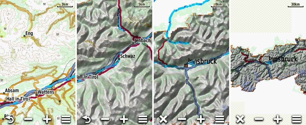
Screenshots from DEM on Oregon 600 - only Austria in this example. From Left: 3km scale (DEM not shown with Auto mode), 5km, 8km and 30km.
How to Use
Right now this is first version - it should work but I hope to still improve them a bit. To use them simply copy the .img file to the /garmin directory on your mSD card, then activate the mtbmap-DEM-XX (XX standing for abbreviated country) map on your device.
Attention in night mode the relief will never be shown. So if you try it out at night (or without GPS reception sometimes) - you need to deactive the night mode.
Device Setup
You should setup your device to show DEM to auto mode. You can do this in
Map Settings --> Advanced Setup -->Shaded Relief: Auto
If shaded Relief is set to Auto - it will show from 5km zoomed out to infinite (I hope to restrict this in future to 30 or 50km). Always make sure to have the devices Basemap active - it will really speed up map panning when zoomed out a bit.
3 Different Versions
I have only properly tested the first - standard Version - which is also the one I recommend to use. If you however want to try out a DEM shaded relief map for your device with higher detail level / better resolution you can try out the Experimental versions. They are available in Higher Detail, and in Highest Detail.
Note you should only send one version to your GPS device at a time from a single country. Else your device may not boot. However for testing you can e.g. use the Standard Europe DEM Overview map, and the Higher Detail DEM map from a single country like Germany or Alps.
Note also that the Higher Detail, and Highest Detail experimental versions have not been tested thoroughly - and they mainly make sense if you set Map Settings --> Advanced Setup -->Shaded Relief: Show Always.
If you want to know the last update time, MD5 Checksum or exact filesize of a download - just look into the MD5 link that follows each download.
Contourlines/DEM data:
The altitude data for the contourlines is from varying sources in the following priority (if available):
- LIDAR data from open government data and other openly available sources - collected and converted to hgt format by - Sonny - DEM Altitude Models This data is very very high quality and resolution - there is no better open data available according to my knowledge.
- ALOS World 3D30 - überall zwischen N60° und S60°
- SRTM 1" v3.0 - very rarely for some tiles missing in ALOS data - also only between N60° and S60°.
- Viewfinderpanormas 1" - then 3" - above N60° / below S60° as there is no SRTM data nor ALOS or LIDAR Data avialble.
- SRTM 3" v3.0 (very very rarely, 8 tiles only)
more exact info which data is used where - inside the copyright.txt files.
Free Sample download of Austria if you have no VeloMap membership:
- Standard Detail: DEM -Austria (MD5)
- Higher Detail: DEM -Austria (MD5)
- Highest Detail: DEM -Austria (MD5)


Leave a Reply
You must be logged in to post a comment.