Note: As Qlandkarte GT is not developed anymore since a couple of years - I actually recommend you to use Basecamp 4.6.2 via WineHQ instead. Also Mapsource 6.16.3 can be use via WineHQ.
See here for Notes Regarding WineHQ:
Basecamp: https://appdb.winehq.org/objectManager.php?sClass=version&iId=39762
Mapsource: https://appdb.winehq.org/objectManager.php?sClass=application&iId=227
Both Basecamp and Mapsource should run with WineHD. You need the additional packages:
winetricks dotnet461
winetricks gdiplus
If you install Mapsource instead of Basecamp the first time/without having a map installed - run:
unzip MapSource\_6163.exe
wine msiexec /i MSmain.msi
wine Setup.exe
Installation instructions from Wine:
winetricks dotnet461
wget https://download.garmin.com/software/BaseCampLegacy_425.exe
wine BaseCampLegacy_425.exe
Install latest version in Windows
https://www8.garmin.com/support/download_details.jsp?id=4435
Copy C:/Program Files/Garmin/ from Windows install of BaseCamp
Contents
Preparations, Downloads Installing Qlandkarte GT
The Successor - QMapShack works with gmapsupp.img format maps - which you can download here: https://openmtbmap.org/download/gmapsupp/
What is Qlandkarte GT? Well it's an open source universal offline map viewer. It can both display Raster maps and Garmin vector .img maps. You can even overlay your raster maps with vector maps. As Qlandkarte GT is constantly improving, I recommend you to always use the latest version. Qlandkarte GT is available for all major desktop platforms (Linux, Mac OSx and Windows).
Forthmost of course, Qlandkarte GT will be of interest to Linux users in conjunction with OpenMTBMaps and VeloMaps, as there is no Garmin program for Linux natively (Mapsource runs under Wine though)....
1. Install and get Qlandkarte GT from Qlandkarte.org - Click on Download then select your OS
2. If not yet installed, make sure you can unpack lzma2 files. The OpenMTBMap .exe Windows files are simple lzma files (though I plan to change that to lzma2 sometimes soon).
apt-get install 7z or aptitude install 7z
3. Download the OpenMTBMap or VeloMap of your choice from here: OpenMTBMap.org/download/odbl/ respectively www.VeloMap.org/download/odbl/
4. Put the maps into a directory of your choice - e.g. openmtbmap_austria for the the austrian OpenMTBMap and then unpack it
7z x -y -openmtbmap_austria mtbaustria.exe
Alternatively if you prefer not to use commandline, rename mtbaustria.exe to mtbaustria.7z, and then right click it in your file manager to unpack it!
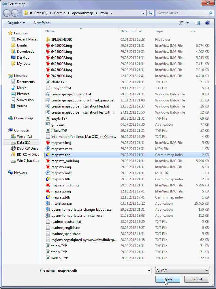
5. For some maps, you need to unpack the contourlines too. Make sure all 6*.img and 7*.img as well as *.tdb and mdr.img and *.typ files, are in the same folder - and not in subfolders.
Here is a screenshot of what needs to be in a single folder (this plus 6*.img - the example is from the Latvia Map) - you can see 6*.img - theese are the map files. 7*.img - theese are the contourlines and some more files like *.TYP - which are defining the layout of the maps, or mapset* files, which are like the index for the maps.
Using the Maps with Qlandkarte GT
First of all, in case of questions - here is a good help: QLandkarte_GT Help
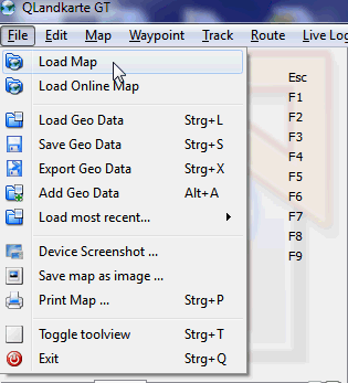
1. We click on Load Map (in German Karte Öffnen):
2. We have to select the main map file - This is always the *.tdb file. Note that there are three *.tdb files:
mapsetc --- Theese are the mapset files which integrate the contourlines into the map
mapsetx --- Theese are the mapset files which do not integrate the contourlines into the map
mapsetz --- Theese mapset files are for you if you want to have a separate contourlines only map.
The normal way is to load the map - using the mapsetc.tdb file - however you could also load the map without contourlines (mapsetx) and load the contourlines as a separate map (mapsetz).
Here I select mapsetc.tdb and click on open to continue.
3. Now we have to select the according overview map. You need to choose the same mapset? as chosen before. Therefore I click on mapsetc.img and click on open.

4. Voila - that's it. You can see the map added to your list of vector maps in the left window. If you load more maps, they will be added there. Now you can zoom into the map.
5. Zooming in the map appears.
6. Choosing the map layout and map detail for a given zoom level:
When you look in the lower right edge of the Qlandkarte GT window - you find some dropdown menus.
Detail: If you select a + value, more information is shown even while zoomed out further. If however too much details obstruct your view, or make loading the map slow, you can set it to "-"
Night: OpenMTBMaps have no separate night layout - hence this won't change anything.
Unspecified/Language: Please leave this on Unspecified - I have not translated all the relevant files. If you select German or English - then some POI or lines won't show labels.
easy/Layout: This is the most interesting dropdown menu - here you can quickly change the layout - for working with Qlandkarte GT - I recommend trad?? (?? stading for the country prefix).
7. After we have chosed tradlv - the map now looks like this:
The VeloMaps have 3 Layouts:
- velo --- Classic VeloMap layout for trekking or tour cycling.
- race --- Reduced information for roadbiking / race cycling.
and
- trdn --- Mapsource/Basecamp/Qlandkarte_GT/Desktop --- General big screen/resolution layout. It is the easiest to understand layout and optimized for big screens (800x600 or bigger). Street colors similar to google maps. Medium contrast - therefore bad for GPS use.
The OpenMTBMap maps have 5 Layouts - choose according to your needs:
*clas --- Classic - optimized for Vista/Legend/edge_705 series
*thin --- thinner tracks and pathes - optimized for Gpsmap60/76 or Dakota series
*wide --- high contrast layout, like classic but with white forest and wider streets/lines - optimized for Oregon/Colorado dull displays
*easy --- Simple Layout with (nearly) no additional info over traditional topo maps. Same width as Classic. No add. lines for (mtb:scale(:uphill)/cycleway=*/sac_scale)
*hike --- Similar to easy but fully optimized for hiking.
and
*trad --- Mapsource/Basecamp/Qlandkarte_GT/Desktop --- General big screen/resolution layout. It is the easiest to understand layout and optimized for big screens (800x600 or bigger). Street colors similar to google maps. Medium contrast - therefore bad for GPS use.
Updating the maps:
Simply unpack the new .exe, and overwrite the old data - before Qlandkarte opens, it will ask you again to select the overview map again - so usually (see instructions above) you will select mapsetc.img and click on open to continue.
Working with the maps and uploading them to your Garmin GPS:
I might in future add some more info here - for right now, please read the Qlandkarte online help:


Hallo zusammen,
ich nutze seit etlichen Jahren VeloMap-Karten auf Qmapshack/Linux Mint. Die XXXX.img Files generiere ich jetzt neuerdings mittels mkgmap und gmt (create_omtb_garmin_img.sh). Das funktioniert bei “kleineren” Karten bis 1,5GB z.B. Italien sehr schnell und fehlerfrei. Bei den größeren Karten (z.B. Deutschland und Frankreich) bricht die ZSH-Shell mit der Fehlermeldung “ERROR: Could not find 6*.img file after extracting velogermany.exe” ab. Ich konnte im Netz keine Anregungen finden. Unterscheidet sich die Datenstruktur zwischen den ~1GB und 2GB Karten, oder kämen da Hardwareprobleme in Betracht. Das benutzte Lapi hat einen i5 Prozessor und 8GB RAM – da dürfte sich kein Mangel ergeben.
Ich bedanke mich schon mal vorab für Ratschläge.
Viele Grüße,
Klaus
8GB Ram könnten wirklich zuwenig sein. Bzw evtl bist du schon über der 4GB Grenze? Du musst einfach das Skript mal öffnen im Text Editor, die Ausgabe komplett in der Shell anzeigen und den echten Fehler von mkgmap rausfinden. Da das wenn alles passt verwirrt habe ich die Ausgabe nach Null geschickt/versteckt.
oh sorry, ich habe das damals falsch verstanden. Die Deutschland Karte, oder auch Frankreich haben weil nicht entpackbar eine eigene Linux Version zum Download.
QLandkarte ist offensichtlich nicht mehr vergfügbar, weder im Repository von Linux Mint noch auf der Projektseite. Es wird allein Qmapshack angeboten. Bisher verwende ich Basecamp unter Windows, um Karten auf mein altes Etrex zu laden, möchte aber in Zukunft eine Anwendung unter Linux verwenden. Gibt es hierzu Empfehlungen?
Verstehe die Anmerkung “Man kann daher natürlich kein .Typ File schnell auswählen.” nicht. Bedeutet dies, dass ich unter Qmapschack keine VeloMap-Karte verwenden kann oder nur dass ich auf Garmin-Geräte beschränkt bin, wenn ich Karten auf das Gerät übertragen möchte?
Du kannst das Layout nicht schnell ändern. Dazu musst du das beiliegende bash Skript nutzen.
Gibt es auch Erfahrungen mit Qmapshack? Soll der Nachfolger von QLandkarte sein und wird unter Linu Mint angeboten. https://github.com/Maproom/qmapshack/wiki
Qmapshack versteht nur Karten im gmapsupp.img Format eine Entscheidung die ich nicht gut finde. Ansonsten ist es in Bezug auf Garmin Karten Recht identisch. Man kann daher natürlich kein .Typ File schnell auswählen.