The next map updates - coming over this weekend will include new contourlines. Actually I updated the contourlines already over the last few months for quite a few countries - but this was only for countries with integrated contourlines. So the next map update of countries like Spain, Norway, Turkey, Europe continent will require an update of the contourlines as well. Note that it can be temporarily for a few hours (up to 16 hours in case of Europe continent map, max 13-14 hours for other maps) that only the new contourlines are online, but the map that belongs to it is not updated yet.
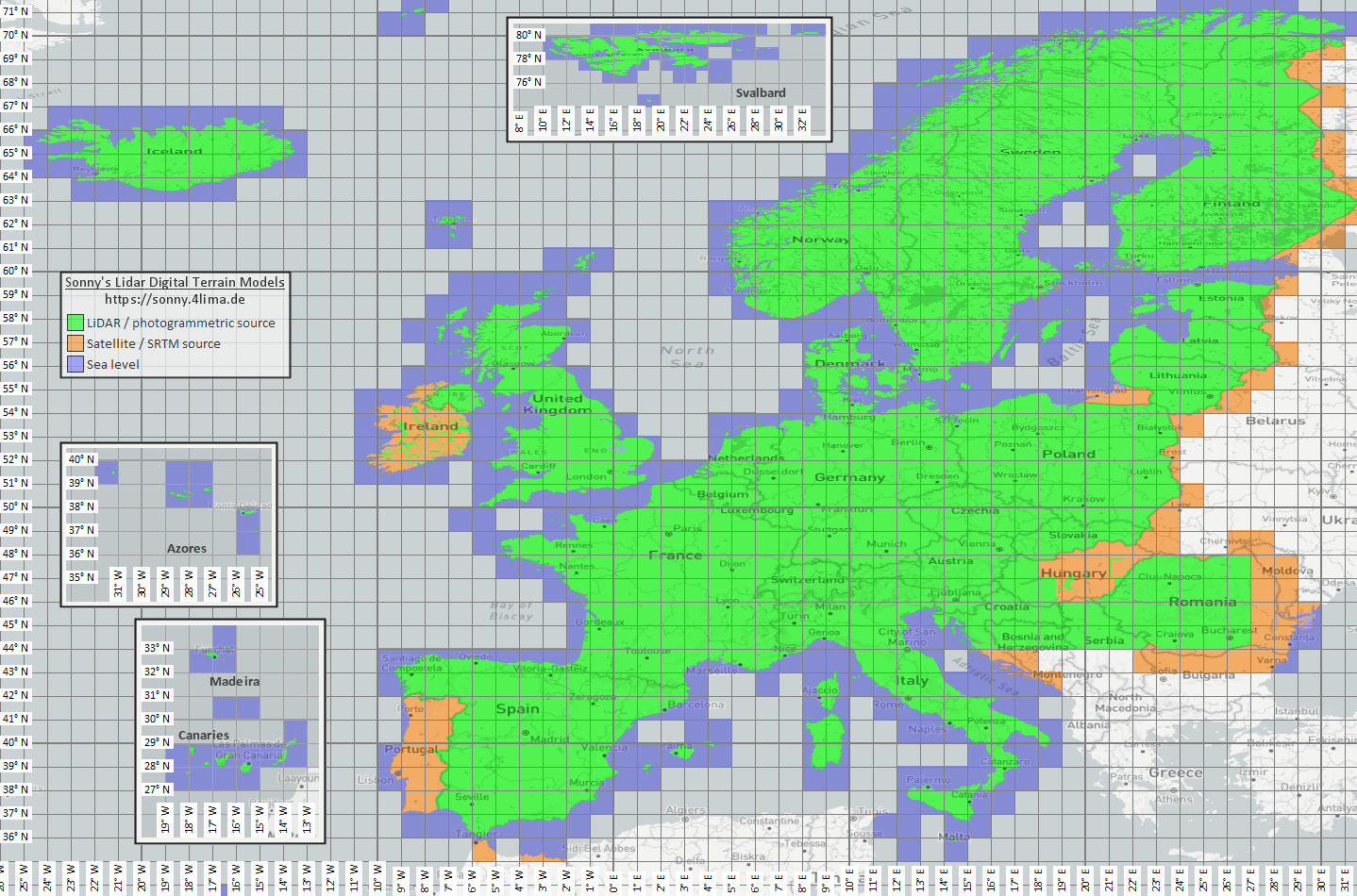
The next Picture shows the coverage of LIDAR DEM sources in my maps after the update (picture by the creator of the DEM files https://sonny.4lima.de/ ). It's the first time for quite a few eastern European countries to have LIDAR DEM data and first update for many parts in Italy as well as other countries. LIDAR DEM sources usually mean that the error in altitude is less than 2-3m even in forest (showing the altitude on the ground, while satellite sourced DEM sources usually have rather the altitude a bit below tree crowns).
Also I changed the 20m equidistance contourlines to show 10m interval up to 50m over sea level. Due to various bugs in the tools used to compile the contourlines - this update took many weeks of work by me as virtually every tool in the toolchain had some bugs that needed to be sorted first.
The other big update was that during the last month I redesigned the layout of the homepage - making it more coherent, exchanging many wordpress plugins that had aged/developped bugs with newer PHP versions - and made a more coherent website layout. I left the overall colour scheme of the website but harmonized many elements, removed many CSS bugs in the theme and some plugins - as well as correct some problems for mobile users. Also finally changed the SSL certificate to Let's Encrypt (I had bought just another 3 year multi domain certificate 3 years ago - as Let's encrypt has no multi domain certificates - and some very old browsers like Internet Explorer on Windows XP were not compatible with SNI - meaning running multiple SSL secured domains from the same IP address using different certificates for each website. However by now there is really no one using those browsers anymore - 3 years ago it was already less than 1% of my visitors and Windws XP is really dead).
Other Updates over the last months were plenty, e.g. updates to OSM usage of valley, railway=halt, adding information=trailblazed and reworked the naming scheme of ways to show a bit more keys/tags concerning road condition (e.g. trail_visibility - shortened as tvVALUE), fixed some access tags, rework of gates, entrances and barriers, improvements to restrooms/toilets, benches, picnik places, remove survey_point (too much clutter) and already last year in October a complete rework of POI visibility on modern Garmin GPS devices according to zoom levels.
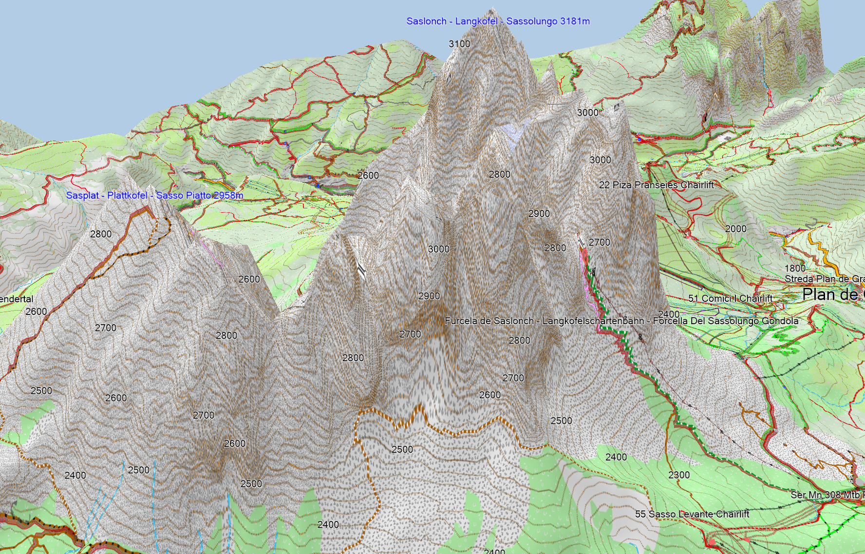
Below the Langkofel, Dolomiti in Italy - really close to reality even though it's so steep.
And here a typical comparison between LIDAR data and old quite good quality data - on first look it doesn't appear very different - but the crevease of the river is much more exact with the new data:
vs old contourlines


Hallo Felix
Ich habe auf auf meinem Laptop die VeloMap_Europe 26.12.2023_NU_Local installiert. Leider werden darauf Campingplaetze erst ab einem Masstab 700m agezeigt, egal was fuer ein Detail Level eingestellt wird. Fuer die Planung einer mehrtaegigen Tour und vor allem unterwegs auf dem Garmin Oregon ist das voellig nutzlos. Dafuer werden Aussichtspunkte schon bei einem Masstab von 3km angezeigt (sowie andere ziemlich ueberfluessige und volatile Features wie Jaegerstaende und Baenkchen). Die Aussichtspunkte werden auch viel zu gross und farblich zu dominant dargestellt. Sie treten oft gehaeuft auf und kleistern die Karte regelrecht zu. Ich habe vor allem wegen der Sichtbarkeit der Campingplatze versucht wieder eine aeltere Version der Europakarte zu installieren. Dort werden die Campingplaetze bereits bei mittlerem Detail-level ab Masstab 5km angezeigt! Mangels aelterer Kontourlinien Version habe ich versucht die neueste zu installieren, erhalte aber dann folgende Fehlermeldung:
Attachment
Gibt es eine Moeglichkeit die passenden Contours herunter zu laden?
Gruss und vielen Dank fuer deine Antwort.
Nein, die alten Höhenlinien habe ich nicht mehr. Kannst du mir bitte mal eine Gegend sagen wo es zu viele Aussichtspunkte gibt? Oft sind Aussichtspunkte aus der Ferne sehr prägnant zu sehen, dafür für die Orientierung sehr sinnvoll. Campingplätze, Hotels, Bed and Breakfast usw – lassen sich auch gut über die Suche finden wenn man sie braucht. Es ist leider immer schwer zu wissen – welche Details wem wichtig sind. Jägerstände/bänkchen sollten definitiv nicht bei 3km angezeigt werden. Sprichst du von Basecamp oder von welchem Garmin Oregon? Deine alte Europakarte die du installieren möchtest ist von welchem Datum? Fürs Oregon könntest du die alte Kart mit aktuellen Höhenlinien nutzen, unter Basecamp geht das natürlich nicht. In Mapsource ist die Anzeige noch einmal anders – dies beachte ich in der Entwicklung nicht mehr – da es zu viele Probleme hat.
Lieber Felix, vielen Dank für deine Mühe. Gerade wenn man auf Langstrecke mit Gepäck in unbekannten Gegenden unterwegs ist, ist es unheimlich hilfreich, wenn man sich auf die geplanten Höhenmeterangaben verlassen kann. Und mit der Europakarte kann man wunderbar in Basecamp über Ländergrenzen hinweg planen. Super, was du da machst!
Hm, das mit den Höhenmeterangaben für die Zukunftige Route ist wieder eine andere Geschichte – das hängt dann auch von der Exaktheit des Weges ab bzw Tunnels usw verfälschen es brutal. Da kann ich nichts verbessern. Die Daten waren diesbezüglich wohl für Höhenmeter Route voraus nicht schlechter – da es da wenig auf Genauigkeit ankommt (am besten dafür wäre ohne DEM die Karte zu übertragen und dann nur Routen nie Tracks nutzen – da dann nur bei überschreiten einer Höhenlinie Meter gezählt werden und nicht mit dem darunter liegenden DEM.