Some people may have noticed that there are 10m contourlines as separate maps on the download pages since about 4 weeks. During the process of generating them I noticed quite a few problems in steep areas that should not have been there. So began a long process of improving the contourlines. The problem was that the filters the map compiler runs against any lines were not suited to contourlines. With the help of others mkgmap is now improved a lot in this regard - and kinda resulting from this also normal maps have improved a lot when zoomed out (thanks to Gerd on his never ending improvements to mkgmap). When zooming out - the further you zoom out now - the bigger the improvement.
For all countries and continent maps - except Asia full continent map (will come in 1-2 months - it is a huge work to create them) there are now 20m equidistance contourlines - and 10m equidistance contourlines. On all maps updated from 30. May 2021 you can select 10m or 20m contourlines. The 10m contourliens are now also integrated into the installer. For Mac OSx they are integrated too - and while for windows users the 10m contourlines have to be downloaded separately, for OSx most countries already bundle them in the gmapi Installer. I had planned to integrate the 10m contourlines on 9 April 2021 for the 12 year anniversary of the OpenMTBMap website - but that work turned out to be way way bigger than anticipated - it is easy to create 2-3 maps, but creating 180 different countries/regions means everything is way more complicated and more bugs have a chance to appear somewhere in the process.
Less visible updates however also important. I have reworked the whole relations (MTB routes, Bicycle Routes, Hiking Routes) integration. Before it was kinda random if several routes were using the same way - which name was given to the way. Now this is ordered from most important to least important routes. This previously had also caused problems that if say a regional route and a national route shared the same way - and the regional route was handled before the national - when zooming out the national route was not shown. This is now fixed.
Complete overhaul of the windows installers - I spent about 80 hours optimizing the installer to be faster (yes still a bit slow - as they use lzma instead of lzma2 and do not support multithreaded unpacking of data) and correctly integrate the 10m and 20m contourlines. Also hope they are easier to understand now. There is still some work to be done - concerning if you install separate contourlines only map on both VeloMap and OpenMTBMap installer (with contourlines as separate download) - I will integrate a warning for this in the future. It is now also possible to only install a separate contourlines only map without installing the map itself but obviously I do not recommend this. Updating the installers I have often thought about just moving the windows maps to gmapi format - because I then would not need to fuss around with NSIS installers - but there are so many cool things that can be done with NSIS installers, plus the fact the windows format is IMHO still better than the gmapi format (except the windows registry) - that I recommend windows users to stick on using the classic map format.
Old Contourlines based on Lidar Data:
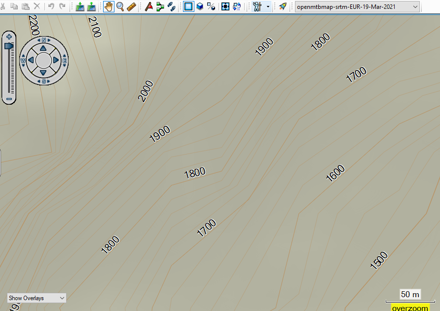
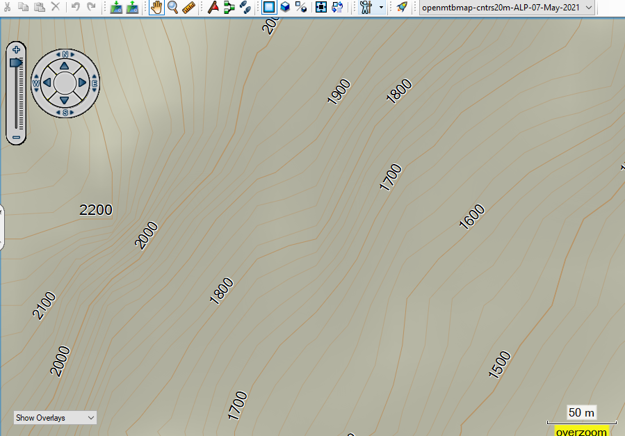
vs the new 20m contourlines - based on the same data but with improved douglas peucker filtering. Notice how the lines are much better aligned to each other. there is no more one contourline crossing another because they were simplified at different locations. This effect will be everywhere - but because the actual distance difference is low - it will only be really visible in very steep areas like on this region. It is a little bit more exact now - but the main difference is that the rounding to the Garmin GPS device is more coordinated.
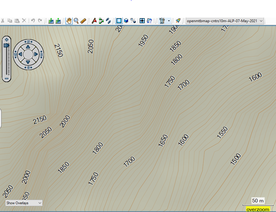
vs the new contourlines at 10m equidistance (and resolution 24 instead of 23 to be even more exact - one point is exact to around 2.8m at resolution 24 vs 5.4m at resolution 23 - this uses a lot more data however. I recommend to use 10m contourlines in hilly or flat areas - and 20m in real mountains like the Alps.
As the maps are updated over the next 24 hours - there will still be slight discrepancies and installers of maps with separate contourlines do not match the map. For OpenMTBMap this should happen much less often than for VeloMap maps (only for english language OpenMTBMap maps with separate contourlines). From Tuesday 01. June this should all be fixed. I will also still add some more gmapsupp.img contourline maps for continents or huge countries which are right now not online yet. As I need to create them manually with MapInstall this will still take a week or so. For Asia continent contourlines gmapsupp.img map is not possible - as it breaks the 4048 tiles limit. The windows 10m and 20m Asia contourlines map will still come in 2-3 weeks or so - there was a mistake on the first try an my server needs over 2 weeks computing nonstop to create them.
If there are no problems that I overlooked - I will update the Europe map in 4-5 days. The contourlines are ready for the Europe map - but I want to wait to see if I maybe missed some bug related to the installer that I simply did not notice. Creating the Europe map is always quite an effort - over 40 hours of compile time (due to 8 versions - 4x OpenMTBMap, 4x VeloMap).
Upcoming Improvements over the next few weeks: I started working on the zoom levels - but stopped this to focus on getting the contourlines updated. I will soon pick this up again and plan to move most ways/trails one zoom level down. Openstreetmap is more and more detailled and I feel it is needed to adapt this. I would prefer doing this only for Europa but I cannot maintain two styles differing in this regard at the same time. Most of my users use the maps in Europe and here it is simply better to have some features appearing later. I already overworked the details when zoomed out further - and think there was a big improvement. The main problem is rivers - I spent hours trying to work around the inconsistencies in river mapping in OSM and making sure important rivers show in lower zoom levels. However the problem being here is that rivers are more and more mapped with relations - and many of those super relations for rivers like the Danube or other major rivers are broken or partly missing. It is better now than 2-3 months ago in my maps - but not perfect. Essentially it would be best to move away from OSM to another more consistent data source for the very far zoomed out regions - but I do not know how to do - nor which data source would be compatible.
Also I am working on a new layout - for people who prefer more of a classic hiking map look. I hope to finish it in 4-5 weeks. I still need some time testing it out in practice on my Edge, Oregon and etrex devices. I still feel there needs to be some adaptions for better contrast - typical paper maps are simply different. However I aim to make it easy to understand for people just used to topographic paper maps. My opinion is still that the color layout I am using right now is way better than the classic maps in readability and possibility to transmit information. All other OSM based maps contain way less information about the quality / usability of ways. But some people are just overwhelmed by it - so I will create that layout for them.
Unrelated to this - I have overworked both OpenMTBMap and VeloMap websites - and included many tutorial videos. Many things were a bit outdated and I tried to correct most of them. Having so much content also means it takes a lot of time to keep it up to date. Most video tutorials are aimed at beginners - however the route planning videos for example may still contain a few tips and tricks also for regular users. I still feel that written tutorials are better than video tutorials - but because some people prefer seeing video tutorials I created video tutorials for nearly all common desktop related tasks with the OpenMTBMaps and VeloMaps. Somewhere on my roadmap are also videos using GPS devices - but they are more complicated to produce so still need some time. I will also still create a video comparing the different layouts and explaining a bit more about them. However that will have to wait until I have finished the classic topographic layout.


Wenn ich die 10m Hööhenlinien herunterlade und öffnen , öffnet sich sofort die Basecamp, aber die höhenlinien sind nicht sichtbar.
Die Höhenlinien wählst du im Installer der Karte anstelle der 20m Höhenlinien aus. Der Installer des Landes kann sie integrieren und/oder separat installieren
I am unable to get 10 metre contours to be displayed on the VeloMap of Great Britain. No contour lines are visible on either Basecamp or my Edge 1000 Touring. If I select to use 20 metre contours, they are shown. If I use the OpenMTBMap they are displayed. The map files are dated 11/06/2021.
How do I get the 10 metre contours to display?
You can only send the 10m contourlines once! Actually you are lucky your edge 1000 is still booting up. Send them as separate map – and send the maps without contourlines – or use the gmapsupp.img downloads. This applies to all contourlines that are a separate download. Not allowed to be sent twice.
Therefore they are also only shown once in Basecamp! I want to prevent people sending them twice! In basecamp they can only show either with VeloMap or with OpenMTBMap. Everything works as intended
If you need VeloMap and OpenMTBMAP both with 10m contourlines in Basecamp – then use UK and Europe map. That way is okay. You can have 10m for each country once – and continents are like countries in this regard.
oh sorry, I just noticed I introduced a bug to the 10m VeloMap contourlines in the last update. I will fix it for the next update
but also with this bug fixed – you are not allowed to send the contourlines then with both VeloMap and OpenMTBMAP. I should actually put a warning into the installer – I think I can check for that.
But how do I extract just the contour lines from either the Velo or MTB map to copy onto my Garmin to go with the Velo and MTB map files that I have already put there?
by installing the separate contourlines only map – and not integrating them into the map before sending. Or by using the gmapsupp.img downloads. VeloMaps will be updated by tomorrow morning with 10m contourlines working again (right now they are broken for those countries where contourlines are integrated for 20m, where 20m is separate download too, the 10m contourlines are working also integrated into the map).
For Mac OSx this has been possible already – for Windows installer the next update brings the possibility to change the layout for the contourlines only maps. This had been missing (was over 20 hours to implement this and fix all bugs related to it). So the main things left on my todo list now is the rework of the detail level for the maps – and the new topographic layout. Admittedly the biggest points work wise.
Hammer! Danke für die viele gute Arbeit!!!
Just a note to anyone reading there – the 10m contourlines right now have a bug that in Basecamp/on your GPS device you cannot see an altitude profile. This will be fixed in the next update.