Well, long time no see, here is another newsletter (and probably the longest ever) from Openmtmbap.org & www.VeloMap.org
New maps as well as old CCBYSA 2.0 maps up for download now!
(eine abgekürzte Version der News auf Deutsch gibt es hier: http://www.mtb-news.de/forum/showthread.php?p=9860635#post9860635 )
Maybe many of you thought, that there is no news due to me being on holidays, but actually I tried to work all of July and August, and improved many many things on the OpenMTBMap and VeloMap. But first of all, let's start with the license change.
The last map updates were on July 13, one day before the redaction bot started to take out all data from OSM, that wasn't compatible with the new odbl license. This gave me the chance to try out and hack away; to bring many improvements and some new features.
Yesterday, it was announced that the next planet file will be published under odbl. Therefore I used the last CCBYSA data, to compile new maps. Reason being, that the coastlines and boundaries are still from pre-redaction time, and hence no flooding should occur, and search working a bit better, and I don't yet need to change the license.
Consequently as of today you can find both the old maps from 13 July to download, as well as the new (last time CCBYSA 2.0) maps for download. Next map update will be in a week or two, and the license will then be odbl.
Changes to VeloMap - New Racing Bicycle Layout - New Mode for Roadbiking
Well, it's been quite some time, that I just dragged the VeloMap along besides the OpenMTBMap. Backporting changes, without really developing it further. Finally however, I decided, let's improve the VeloMaps and adapt it more for roadbiking. The big change is that the VeloMap have an all new "Racing Bicycle" layout / mode, which is 100% aimed at roadbiking.
Up to now the VeloMap was simply a topographic map made for tour cycling. Now it's also a normal street map, with additional info for commuting and roadbiking. It features wide streets and very high contrast. Everything that hinders you from concentrating where to go or where to turn, has been taken out. This means for example that POI for shops have been made invisible, buildings taken out, and so on. What it still shows of course, are contourlines, and other stuff important for roadbiking
On the other hand the separation between paved and unpaved ways/streets has become even clearer. So you won't get lost on a cycleway that changes halfway from paved asphalt to gravel because you didn't notice it on the map.
Overall, the new Racing Bicycle layout, is more of a traditional road map, adding some of the great data openstreetmap has on top of it. (e.g. cycleroutes, oneway information for cyclists, the most needed POI like water or restaurants and bikeshops, but not all of the information that you would get from a topographic map).
So below let's have a look at a screenshot of Center Vienna - to see what changed. First let's go with the old classic VeloMap layout (which is made for handheld device screens only - to be fair):
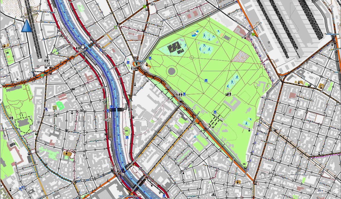
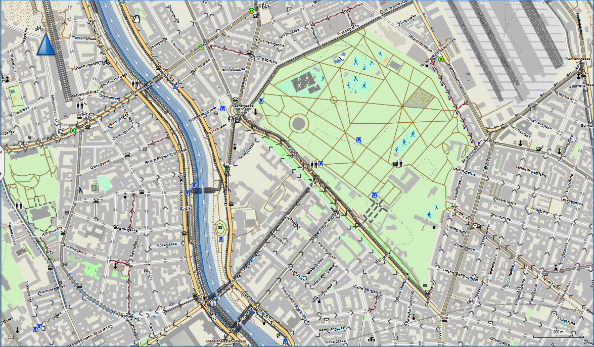
Mind, this above classic layout is not made for viewing on such a big screen. That's what the Desktop / Traditional layout was for, and it's already much nicer:
But now let's have a look at the all new racing bicycle layout. It gives even better orientation, as it is reduced to the max. On the other hand, on your GPS it will look even better, as it's still heavily optimized for small screens on handheld devices:
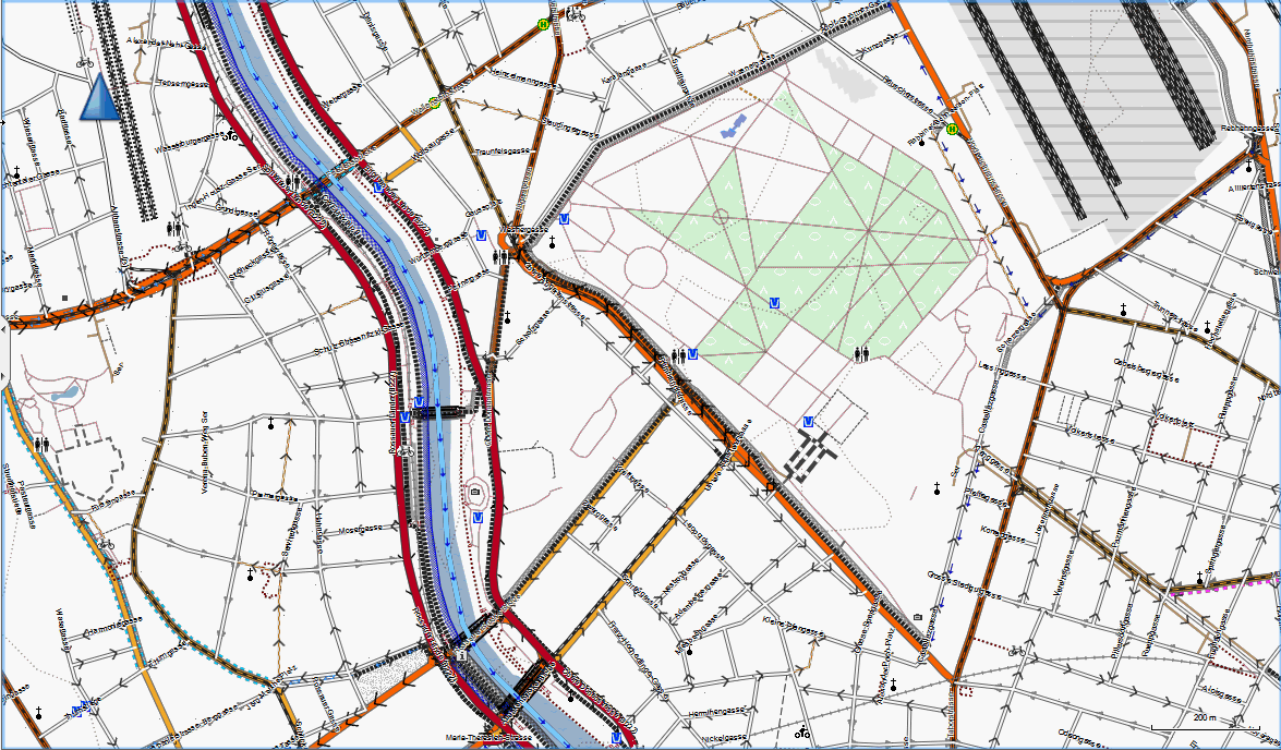
Yeah I'm really stoked about the new VeloMap racing bicyle layout. Actually the VeloMap is now two maps in one, because you have one mode (autorouting as well as layout) for roadbiking, and one mode mode for trekking/tour cycling.
So please help spread the word all over the internet and spam your friends with emails, or tell others in forums! To spread the message of the first real maps for roadbiking made from Openstreetmap data ever (and actually I would say the first ever really specialized roadbike maps)!!!!
Adapting both OpenMTBMap and VeloMap to the Activity Routing devices and Basecamp
Well, even though the outcome might seem unspectacular, it was over 100 hours of analyzing with artificial testmaps, to see how the new Basecamp 3.3 as well as an Oregon 450 and an etrex 30 do autoroute. My aim was clear, the maps have to work both with the old devices and Mapsource, as well as the new devices and Basecamp. After testing and debugging for ages, I managed to get a great result. The setup you have to do in the autorouting settings is different - so be sure to check https://openmtbmap.org/about-2/autorouting/ and for VeloMap https://www.velomap.org/velomaporg/autorouting/ to see what you have to do.
I have explained all settings, but also given a short advice on how to setup the autorouting for CrossCountry, Allmountain/Enduro, Vertride/Hiking for the OpenMTBMap, and Trekking/Tour Cycling, Roadbiking as well as Commuting for the VeloMaps.
Bugfixes:
Well I tried to push through the updates since several days, knowing that it would be the last time, I render the July map data, and so since Monday, my map rendering server is running hot on a long queue of requests to rerender the maps, as more or less every day, some little bugs popped up, and me being a perfectionist, re-rendering the maps all over. (well the new odbl cleaned data was stuck several weeks without updates at geofabrik, meaning as of writing this now (Friday night) the new maps are rerendered just once more....
- highway=unclassified & cycleway=opposite, was not routable against the general direction of traffic
- ferries were not routable if part of a cycleroute or mtbroute - now if part of a route even higher priority. Same for aerialways
- route=hiking now also shown if mtbroute is on the same way (furthermore the separate name is shown on mouseover)
- fixes for route=foot / route=hiking depending on length.
- highway=path & bicycle=designated was not shown (it was only routable).
- Some bridges were missing, if part of a cycleroute or mtbroute
- Oh and as of Saturday the bug making veloeurope.exe not working, is solved too now.
OpenMTBMap 2012 Alps Discovery Tour
Well, all the work needs to come to an end... After virtually working 16 hours daily for the last two and half weeks, the next three weeks will be about testing the maps on the trail, and trying to get my fitness into a reasonable state again. I'll be starting Monday in Tux, Zillertal Austria, and then mak my way to Valais Switzerland together with a friend. We'll be mostly camping and t'would be nice to meet up with other bikers during this trip. I'll update this post on the homepage whenever I have internet, so you can see where to meet us up. We're looking forward for technical riding, so mtb:scale=4 is what we aspire to ride down. Riding up on dirtroads or carrying, with the occasional bus or gondola sandwiched in. Just drop me a mail if you want to meet and join. We usually ride 1300 to 2000m uphill every day, depending on the difficulty, and 16kg bikes don't pedal that fast....
I'll finish it off from 23-30 September in Leogang, with a Bikepark and Freeride Guide education (with the intention of better being able to know what bike tour operators want, so that I can kick out the not really targeted advertisements here, and rather get good tour operators offer their trips here).
Oh and as always, just a little reminder. Thank's to many people supporting me with donations, I'm able to do all that work. Please continue so, and especially if you haven't got an account yet, why not do it now. Only by getting new people on the boat, I'm able to continue improving the maps. Also watch out for news in the future, you'll soon be able to use OpenMTBMaps and VeloMaps on your Android phone.


Leave a Reply
You must be logged in to post a comment.